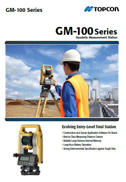
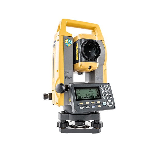
Total Station, 5″, GM-105
- Laser Point နှင့် Point Guide ပါရှိခြင်းကြောင့် မိမိတိုင်းတာလိုသော Point အားအလွယ်တကူတိုင်းတာနိုင်ခြင်း
- Internal Memory Point 50000 အထိ မှတ်သားနိုင်ခြင်း
- Prism မပါဘဲ မီတာ 800 အထိ တိုင်းတာနိုင်ခြင်း
- Memory Stick ဖြင့် Download/upload ပြုလုပ်နိုင်ခြင်း
Description
The GM-100 series also features dual axis compensation, 32 GB USB, Bluetooth to 10m and TSshield telematics for ultimate security and investment protection.
- 6,000m prism range 1.5mm accuracy
- Easy access USB memory with 32 GB storage
- 1″ angle accuracy encoder system with exclusive IACS
- Rugged, waterproof/dustproof magnesium-alloy housing
- 28 hour battery life (eco mode)
GM-100 Series Specification
| Telescope | 30x / 2.5″ |
| Others | Length : 171mm (6.7in.), Objective aperture : 45mm (1.8in.) (48mm (1.9in.) for EDM), Image: Erect, Field of view: 1°30′ (26m/1,000m), Minimum focus: 1.3m (4.3ft.) Reticle illumination: 5 brightness levels |
| Dual-axis compensator | Dual-axis liquid tilt sensor, working range: ±6′ |
| Collimation compensation | On/Off (selectable) |
| Laser output | Reflectorless mode : Class 3R / Prism/sheet mode : Class 1 |
| Operating system | Linux |
| Display / Keyboard | Graphic LCD, 192 x 80 dots, backlight, contrast adjustment / Alphanumeric keyboard / 28 keys with backlight |
| Control panel location | On both faces |
| Trigger key | Yes (right side) |
| Guide light | Green LED (524nm) and Red LED (626nm), Operating range: 1.3 to 150m (4.3 to 490ft.) |
| Laser-pointer | Coaxial red laser using EDM beam |
| Dust and water protection / Operating temperature | IP66 (IEC 60529:2001) / -20 to +60ºC (-4 to +140ºF) |
| Size with handle | 183(W)x 181(D)x 348(H)mm |
| Instrument height | 192.5mm from tribrach mounting surface |
| Weight with battery & tribrach | Approx. 5.3kg (11.7lb) |
| Battery | Li-ion rechargeable battery BDC70 |
| Operating time (20ºC) | BDC70: Approx. 28hours |
| On board | •REM Measurement •3D Coordinate Measurement •Resection •Stake Out •Topography Observation •Offset Measurement •Missing Line Measurement •Surface Area Calculation •Route Surveying •Point to Line |
For detailed specifications refer to the Product Brochure.
Topcon
GM-100 Series (Geodetic Measurement Station)
Cross-Sectional Survey
By using the MLM (Missing Line Measurement) program, the height di erence between points can be calculated for leveling. Also, you can save time on reflectorless mode to measure a number of points of variation in a large area.
Topographic Survey
The trigger key, or measuring distance key, helps you perform topography quickly while continuously viewing through the telescope. Also, the long distance measuring
range reduces the number of the instrument changes for
more ecient working time.
You must be logged in to post a review.

 Shop
Shop
Reviews
There are no reviews yet.