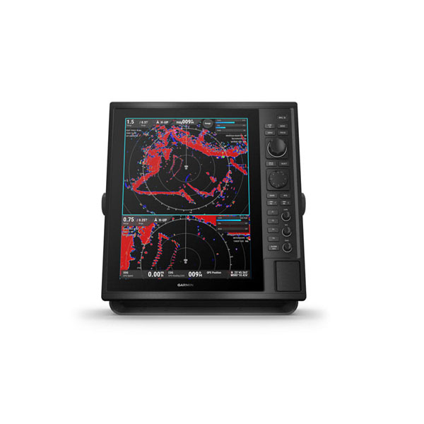
GPS-Marine, Radar Display CR1522, 15
- Under the sun, yet the large, glass-bonded screen is still readable.
- Being on the radar means offering both traditional and solid-state.
- A good track record starts with simplify Target Tracking (TT). Follow up to 50 targets.
- Go long (or short) with dual-range capabilities for visibility.
- Coast along with both BlueChart and BlueChart Vision charts.
Description
Basic Principles of Radars
Radar, originally an acronym for Radio Detection and Ranging, is a detection system that determines the position and velocity of objects by transmitting radio waves outward and processing the radio waves reflected off the objects.
Development of Marine Radars
Marine radars were developed during the period of the Second World War. Before its development, seafarers had to rely on sound waves generated by a whistle, a gunshot, or a bell sound to determine the direction and distance of obstacles when visibility is low. Since its invention, marine radars are used to detect other vessels or land obstacles and assist in navigation and collision avoidance at sea. A rotating antenna sweeps the surface of water around the ship toward the horizon with a narrow beam of microwave signals. The antenna then listens for bouncebacks of the signal to determine the bearing, distance, and motion of detected targets based on the variations in the reflected signals. The radar uses these information to map out the ship’s surroundings on the radar display in a bird’s eye view.
Determining the Bearing
As the antenna rotates in the 360° circle, electronic pulses are sent out at slightly different bearings. The signals, and their reflected echoes, travel at the speed of light (roughly 161,785 nautical miles per second), and echoes are received almost instantaneously when they reflect off objects. The bearing of a target is therefore the angle of the antenna at which the echoes are received.
Determining the Range
The range, or the distance to a target, is calculated by multiplying half the speed of light by the time difference between the transmission and reception of a signal. The speed is halved because the signal traveled the distance twice (to and from the target).
Displaying Relative Positions
The calculated relative positions of detected targets are plotted on the radar display with the own ship position usually at the center. The plot is refreshed as the antenna rotates, and the relative motions and speeds of targets can also be displayed.
Radar Performance
The performance of a radar system can be affected by many factors including the beam width, pulse length, cable length, antenna height, or the weather. The performance can be gauged by the detection range, the range/bearing accuracy, range/bearing resolution, or the ability to distinguish false echoes (see Chapter 4).
NOTE: Cable length won’t be a factor until the length exceeds 100 m, after which the performance starts to decrease.
Maximum Range
The detection range of a radar depends on the height of the antenna and can be affected by the weather. The high-frequency radio waves pass through the atmosphere following the curvature of the Earth, and is able to detect targets beyond the optical horizon due to
the properties of the air molecules. Assuming normal atmospheric conditions, the maximum range (in nautical miles) can be estimated by the equation:
Maximum range = 2.2 x (√h1 + √h2)
h1: height of antenna above sea level (in meters)
h2: height of potential target above sea level (in meters)
Radar Resolution and Accuracy
The resolution and accuracy in the displayed bearing and range of a target is crucial in navigation and collision avoidance, and is dependent on the antenna length, the pulse length, the beam width, and the initial calibration of the heading. Higher resolution allows the radar to display targets that are close together either at the same range side by side separated by a few degrees, or at different distances from own ship on the same bearing.
Specifications
| PHYSICAL DIMENSIONS (W x H x D) | 355 x 376.7 x 82.7 mm |
| DISPLAY SIZE | 15″ diagonal, (228.1 x 304.1 mm diagonal) |
| DISPLAY RESOLUTION | 1024 x 768 pixels |
| DISPLAY TYPE | XGA |
| WEIGHT | 3.7 kg (5.7 kg with bail mount) |
| WATER RATING | IP26 & IP27 (IEC60529) |
| POWER SUPPLY | 10 to 36 VDC |
| POWER CONSUMPTION | 2.71 A (typical current draw @ 12 VDC) 3 A (Max. current draw @ 12 VDC) |
| ANTENNA | External over BNC |
| MOUNTING OPTIONS | Flat and flush, bail with optional accessory (Garmin does not offer any hardware or accessories for a flat-mount installation. Professional tools and knowledge are required.) |
| RECEIVER | 10 Hz GPS/GLONASS/GALILEO/BEIDOU/QZSS/GAGAN AND SBAS |
| Multi-languages support | English, Simplified Chinese, Traditional Chinese, Japanese, Korean, Thai, Indonesia Bahasa, Malaysia Bahasa, Vietnamese, Burmese, Hindi, Gujarat |
For detailed specifications refer to the Product Brochure.

GARMIN GPS
Radar Display CR1522
All route and navigation lines displayed on the device are intended to provide general guidance to identify proper channels, and are not intended to be strictly followed. Always refer to the navaids and conditions on the water when navigating to avoid groundings or hazards that could result in vessel damage, personal injury, or death.
You must be logged in to post a review.


 Shop
Shop
Reviews
There are no reviews yet.