Montana 680 , GPS
- Touch Screen ဖြင့် အသုံးပြုနိုင်ခြင်း၊
- 4” လက်မ ကာလာမျက်နှာပြင်၊
- 8 Megapixel Camera ပါဝင်ပြီး ဓာတ်ပုံများအား ကြည်လင်ပြတ်သားစွာ ရိုက်ကူးနိုင်ခြင်း၊
- Micro SD Card ထည့်သွင်းနိုင်ခြင်း၊
- Memory 4GB ပါဝင်ခြင်း၊
- Way Point 10000, Tracks 250, Routes 250, အထိမှတ်သားနိုင်ခြင်း၊
- Barometic Altimeter ဖြင့် အမြင့်ပေ တိုင်းတာနိုင်ခြင်း၊ Battery Type နှစ်မျိုးဖြင့် အသုံးပြုနိုင်ခြင်း။
Rugged GPS/GLONASS with 8 Megapixel Camera and BirdsEye Subscription
This price is inclusive of Commercial Tax 5%.
Description
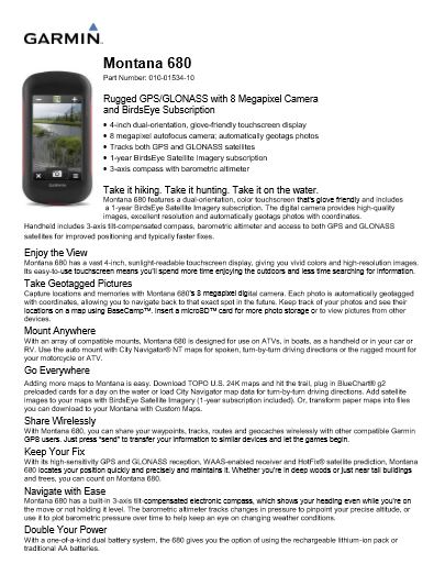
Montana 680 features a dual-orientation, color touchscreen that’s glove friendly and includes a 1-year BirdsEye Satellite Imagery subscription. The digital camera provides high-quality images, excellent resolution and automatically geotags photos with coordinates.
Handheld includes 3-axis tilt-compensated compass, barometric altimeter and access to both GPS and GLONASS satellites for improved positioning and typically faster fixes.
Physical & Performance
| Physical dimensions | 2.9″ x 5.7″ x 1.4″ (7.48 x 14.42 x 3.64 cm) |
| Display size, WxH | 10.2 oz (289 g) with included lithium-ion battery pack; 11.7 oz (333 g) with 3 AA batteries (not included) |
| Water rating | IPX7 |
| Battery type | Rechargeable lithium-ion (included) or 3 AA batteries (not included); NiMH or Lithium recommended |
| Touchscreen | Yes |
| Display type | Bright, transflective 65k color TFT, dual-orientation touchscreen; sunlight readable |
| Display size | 2″W x 3.5″H (5.06 x 8.93 cm); 4″ diag (10.2 cm) |
| Display resolution | 272 x 480 pixels |
| Battery life | Up to 16 hours (lithium-ion); up to 22 hours (AA batteries) |
| Memory/history | 4 GB |
| High-sensitivity receiver | Yes |
| Interface | High-speed USB and NMEA 0183 compatible |
For detailed specifications refer to the Product Brochure.
GARMIN GPS
Montana 680
Montana 680 features a dual-orientation, color touchscreen that’s glove friendly and includes a 1-year BirdsEye Satellite Imagery subscription. The digital camera provides high-quality images, excellent resolution and automatically geotags photos with coordinates.
Handheld includes 3-axis tilt-compensated compass, barometric altimeter and access to both GPS and GLONASS satellites for improved positioning and typically faster fixes.
You must be logged in to post a review.


 Shop
Shop
Reviews
There are no reviews yet.